By Heather Mendenall, AICP, CCF, M.SAME, and Jason Cook, P.E., M.SAME
After the devastation caused by Hurricane Michael to Tyndall AFB, Fla., planners and leadership went to work seeking solutions to prevent similar outcomes. This took the form of developing a design flood elevation—a metric that could be used to decide how to address potential flooding impacts.
About 250-mi across the Gulf of Mexico at Keesler AFB, Miss., planners also looked at developing their own elevation to guide future development. Tetra Tech was contracted to develop a design flood elevation, with an associated geographic information systems (GIS) model to support it. Based on UFC 3-201-01 (Civil Engineering), a series of recommendations for a single-design flood elevation were developed. However, after reviewing the information, Keesler AFB and a technical advisory committee realized they were not achieving the desired results and the approach may limit flexibility in planning for flooding scenarios. The group suggested looking at the problem in terms of risk: the costs or benefits associated with investing in the facility or not.
The change in direction made the team go back to the drawing board and rethink its approach. This led to the development of Flood-Resiliency Analysis and Mitigation (F-RAM).

each facility, helping target investments. U.S. AIR FORCE PHOTO BY SENIOR AIRMAN KIMBERLY L. MUELLER
MAKING USE OF DATA
Instead of selecting a single design flood elevation for all of Keesler AFB, the F-RAM tool visualizes flooding risk installation-wide and automatically ties the risk levels to mitigation recommendations. These strategies include function and/or facility relocation, particularly for mission criticality, as well as temporary flood barriers, floodproofing retrofits, and utility and ground floor elevation. Importantly, the base can utilize F-RAM to make better decisions on how to apply funding toward resiliency preparedness.
At Keesler, GIS best management practices were applied to develop a database. Historic datasets included Tide Gauge Data from the National Oceanic & Atmospheric Administration. Regionalized sea level change scenarios derived from the Strategic Environmental Research & Development Program also helped provide analysis of potential inundation based on conventional (trend-line) modeling or dynamic (simulated) modeling. While the analytical tools available in the database are significant, the creation of maps to visualize the data is its core function.
The project team looked at different scenarios for storm surge benchmarks and other storm data from the Federal Emergency Management Agency as well as the Hurricane Katrina high watermark. This data provided the cost of the facilities, which can be customized based on the number of stories, construction type, and other details. During their research, the planners discovered a study from Louisiana State University that combined projections for both sea level rise and storm intensity increase. As the local data source, the school had the most robust model that also took
wind effects into consideration. This combined data was used to create the F-RAM tool’s scenario-based approach.
Keesler AFB made decisions about which facilities qualified as critical or non-critical, and which were considered old or new. This allowed the design team to help staff decide what areas of risk applied. Based on that, thresholds could be set and mitigation recommendations developed by the tool, then tailored for need.
CUSTOMIZED SCENARIOS
The F-RAM tool is unique in its ability to mesh a combination of risk factors, cost, and mitigation strategies into a single approach. Since it is so customizable, personnel can run their own scenarios to make intelligent decisions around that risk. Tool parameters also can be modified and facilities reorganized by risk level.
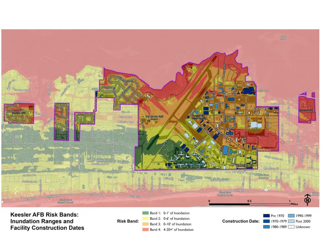
When potential storm scenarios are combined and laid over the base within F-RAM, different risk bands are identified by four colors. The green zone is an area where, over the range of scenarios, flooding is not expected to exceed 1-ft. Yellow risk areas experience 1-ft to 3-ft of flooding, which normally equates to some equipment damage. The orange zone is over 3-ft of flooding, which has potential for structural damage. Any facilities within the red risk band are likely to flood well above the first floor of the facility and be a total loss.
resiliency investments. IMAGE COURTESY TETRA TECH
BENEFITTING COMMUNITIES
The Keesler project provided recommendations for planning, design, and development for each inundation scenario. All deliverables are compatible with service-approved software and integrated directly into the installation development plan GIS. The work included recommendations for integrating design flood elevations into Keesler AFB planning policies and initiatives, to include outside-the-fence compatible use plan implementation.
While F-RAM has only been utilized by Keesler so far, it could be used by the surrounding community because the model goes beyond the fence line. Also, it is regionalized, so a new model could be created for every installation. Any base that keeps accurate GIS information can cut and paste its data into the tool and establish criteria on decision points to generate recommendations.
Commanders can use this tool to assess whether they will make investments into each facility’s resiliency improvements or whether the mission should be moved to a lower risk area. F-RAM can tie mitigation strategies and their associated cost into the tools so that the return on investment can be considered.
In today’s changing resilience environment, because there are many threats that installations face, they need to be more creative in their approach to ensure funds are being spent in the right place to ensure resiliency against potentially devastating impacts.
Heather Mendenall, AICP, CCF, M.SAME, is Director, Federal Master Planning, and Jason Cook, P.E., M.SAME, is Senior Project Manager, Tetra Tech. They can be reached at heather. mendenall@tetratech.com; and jason.cook1@tetratech.com.
More News from TME
-

Developing a Maglev Network for National Defense
A transportation network leveraging superconducting magnetic levitation technologies would bring benefits for logistics, surface transportation, and energy storage, as well as strengthen national defense priorities and the defense industrial base. -

Fulfilling the Mission
Rear Adm. Dean VanderLey, CEC, USN, Commander, Naval Facilities Engineering Systems Command, sits down with TME to discuss the Department of the Navy’s Systems Command for shore facilities and expeditionary equipment, Naval Facilities Engineering Systems Command (NAVFAC) and its varied responsibility that directly support warfighter lethality. -

Strengthening Installation Energy Resilience Through a Community of Practice
The Military Energy Resilience Catalyst strengthens installation energy resilience by providing opportunities for energy practitioners to develop professionally and connect with experts, senior leaders, and colleagues.