By Capt. Alan Heng, USAF, Lt. Col. Daniel Weeks, Ph.D., P.E., M.SAME, USAF, and Christopher Chini, Ph.D.
Using a more optimized site selection methodology that leverages a hybrid approach of both rank-based and mathematical approaches can provide insights into the most viable locations for basing strategics across the Indo-Pacific.

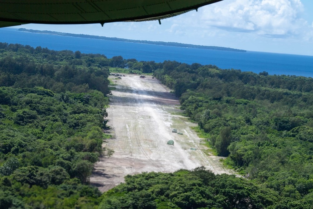
U.S. Air Force photo by Yasuo Osakabe.
Large, fixed installations, traditionally have been the primary means of operating for the U.S. Air Force and enabling its mission to generate airpower. Additionally, the service does also have the capabilities to establish contingency locations as needed—and over the last several decades, it has utilized this approach effectively both in times of war and during intervening peacetime years in an anticipatory capacity. The criteria for assessing the viability of these sites has been quite concise: a runway and a water source.
However, policies and strategy today must be updated in order to create a more agile and dispersed force, particularly in the Indo-Pacific in order to meet China’s pacing challenge as identified in the 2022 National Defense Strategy. While there remains uncertainty around when a conflict may arise, military leadership must prepare for an eventuality in the region by rethinking operations and concepts.
A considered possibility comes from agile combat employment, which utilizes a more adaptive style of basing that has five core elements: posture, command and control, movement and maneuver, protection, and sustainment. This strategic approach relies on smaller, dispersed locations to generate air power. The use of hubs and spokes provides a better solution for posturing and allows for more movement across multiple locations.
An alternative option is for the United States to leverage existing infrastructure and assets from nearby allies and other countries.
In either of these scenarios, using a site selection methodology is critical to select the right locations to invest in.
Site Selection Approach
In the dynamic landscape of military logistics and strategic operations, establishing an efficient hub and spoke model to support agile combat employment is paramount. The current selection of optimal sites hinges on either rank-based or mathematical approaches that consider various criteria to quantifiably assess each location. These factors are then addressed through objectives and constraints, which forms the basis for an effective decision-making process.
The methodology for selecting contingency locations remains undecided, however. Among the models currently used, there are the two primary approaches of rank-based and mathematical. Both of these methods entail the intricate task of selecting optimal sites, a process influenced by multifaceted criteria encompassing cost, environmental considerations, geography, and operational prerequisites.
In the dynamic landscape of military logistics and strategic operations, establishing an efficient hub and spoke model to support agile combat employment is paramount.
Rank-based Methods. Rank-based methods evaluate potential sites based on user-defined criteria. The most prominent methods within rank-based methodologies are the analytical hierarchy process (AHP) and multi-attribute utility theory (MAUT). AHP determines the weighting of each criterion and then identifies the relative importance of each criterion using a pairwise comparison. MAUT incorporates utility functions/curves, which are user-defined, to quantify the suitability based on each criterion.
While rank-based methods provide adaptable and versatile methods for site selection, it still is essential to acknowledge that these methods often operate in isolation, considering individual sites independently. Consequently, these approaches may not fully account for potential interactions when selecting multiple sites.
Mathematical Methods. Mathematical methods provide another approach for solving complex problems, aiming to minimize or maximize an objective function under specified constraints. This approach can help decision-makers find optimal (or near-optimal) solutions. Examples of this method include location allocation and the hub location problem. Both are very similar in identifying facilities and demand points but vary in objective.
These problem-types have been known to play a critical role in site selection and hub-and-spoke modeling to support warehouse, supply chain, and logistical operations. However, a primary limitation involves having a robust dataset that holistically captures all the costs associated with establishing the network.
This conclusion leads to the need for developing a hybrid method that combines the rank-based and mathematical approaches and which balances the gaps between each approach.
Hybrid Methodology
To demonstrate a hybrid methodology for the Indo-Pacific, a previously developed database was used that included utility scores for over 500 public airports within the region. It then was applied in two optimization models. Several scenarios were analyzed within both models to identify different amounts of hubs and spokes based on different constraints.
The first model was analyzed in ArcGIS. The location allocation tool identifies hubs and spokes by minimizing the weighted distances between each airport location. Hubs were identified in Japan, India, Bangladesh, Thailand, Philippines, and Malaysia. Spokes were found in the same hub countries and their neighboring countries.
The second model was analyzed in General Algebraic Modeling System (GAMS), with the objective to maximize the utility scores for hubs and spokes. Hubs were identified in Japan, South Korea, India, Thailand, Vietnam, Australia, and Indonesia. Spokes were found in the same hub countries and their neighboring countries.
Both models successfully identified hubs and spokes that could potentially be used to support agile combat employment within the Indo-Pacific. ArcGIS and GAMS did each yield distinct outcomes, but several commonalities emerged between the two.
First, both models consistently identified hubs and spokes within Japan and South Korea, although with scenario-specific variations in location. These results highlight the fact that these two countries have the highest concentration of high-utility airports among all 26 countries evaluated, offering multiple options for new site selection to support an increased presence. Second, South and Southeast Asia provided public airports with significant potential. Countries in this area could serve as strategic operational hubs, extending coverage and monitoring capabilities across various island chains and the South China Sea.
Realizing Effectiveness
Optimization is a powerful tool that can be leveraged to bolster the objectives outlined in the National Defense Strategy and, ultimately, facilitate the realization of agile combat employment in the Indo-Pacific. The two models created capitalize on existing site selection methodologies while incorporating a hybrid method that blends rank-based techniques to assess the viability of each airport with a mathematical model to formulate a comprehensive solution. Both models successfully located hubs and spokes, with Japan, South Korea, India, Thailand, Vietnam, Malaysia, Indonesia, and Cambodia displaying the most potential.
Decision-makers can harness optimization tools and customize the models based on criteria, objectives, or constraints relevant to them or the problem situation to effectively pinpoint future hub-and-spoke selections. Additional model enhancements may involve the utilization of pre-determined hubs; this would allow optimization to allocate spokes to them more efficiently. Furthermore, models could be segmented into smaller regions or clusters in order to identify individual solutions sought for hubs and spokes in specific countries.
Incorporating optimization to identify future site locations may drive future policy changes and foster increased communication and planning collaboration with other countries.
Capt. Alan Heng, USAF, is Graduate Student, and Lt. Col. Daniel Weeks, Ph.D., P.E., M.SAME, USAF, is Assistant Professor, Air Force Institute of Technology. They can be reached at alan.heng.1@us.af.mil; and daniel.weeks.2@us.af.mil.
Christopher Chini, Ph.D., is Earth Scientist, Pacific Northwest National Laboratory;
christopher.chini@pnnl.gov.
Article published in The Military Engineer, July-August 2024
More News from TME
-

Leading the Way: Partnering for Resiliency and Readiness
TME Interview with Brig. Gen. Patrick Miller, P.E., F.SAME, USAF Commander, Air Force Civil Engineer Center -

Developing Tomorrow’s STEM Workforce Through Partnership
TME recently interviewed leaders of the Panama City Post about paying it forward, their repertoire of STEM outreach, and the benefits of collaborating with similar-minded professional organizations. -

Electrifying Solutions for Military Installations
As military installations implement electrification measures into the future, the challenges they face will not just require innovative technology solutions but embracing a holistic delivery approach implemented early in projects.