Geospatial Engineering
By Lt. Patrick Debroisse, CMH-A, M.SAME, NOAA, and Lt. Cdr. Ian Hanna, USCG
In carrying out the joint response after the Key Bridge collapse, the U.S. Coast Guard and other partner agencies leveraged both internal and external geographic information system expertise to provide data-sharing and near real-time monitoring capabilities.
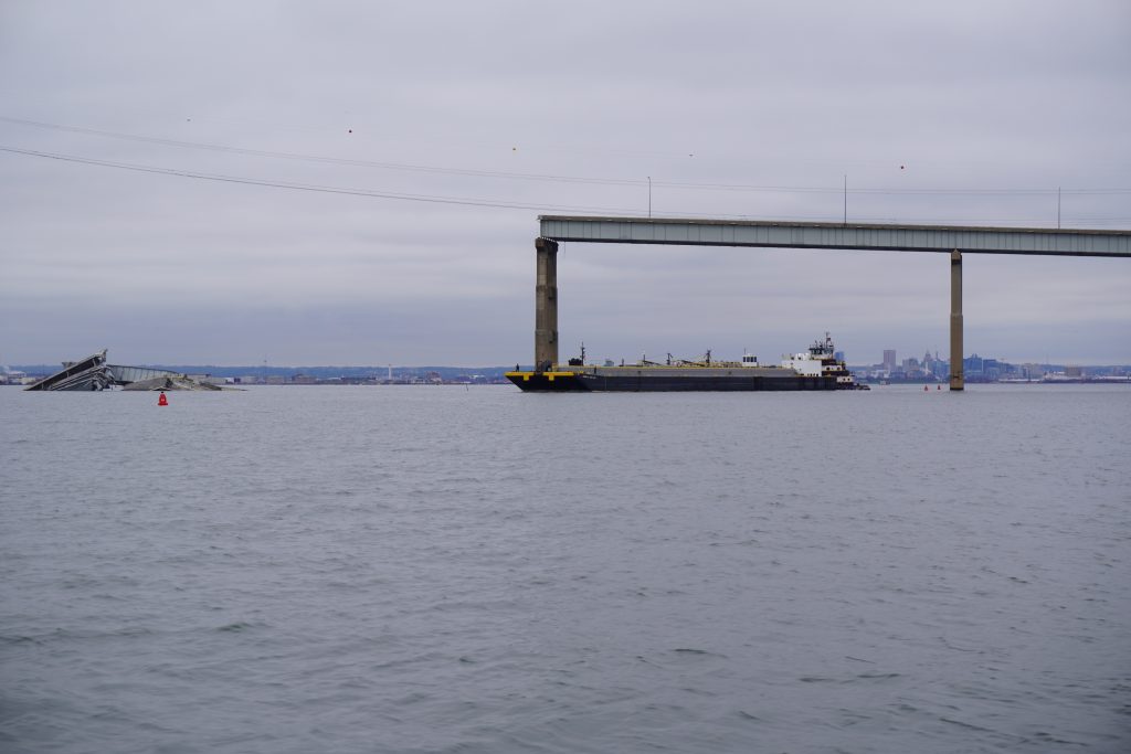
On March 26, 2024, the 984-ft container ship M/V Dali collided with the Francis Scott Key Bridge in Baltimore, resulting in the collapse of the 47-year-old structure and the tragic loss of six roadway workers. The sections of the bridge that fell stretched across approximately 0.5-nm of the Patapsco River; this wreckage completely closed the Port of Baltimore at an estimated local economic cost of $15 million per day.
Soon after the catastrophic event, an Incident Command Post (ICP) was established, which comprised multiple federal, state, and local agencies, to search for survivors and reconstitute the port. With the amount of data requested by the various sub-groups of the ICP and from the Unified Command, it became clear that the standard way of ingesting and portraying these data sets would be insufficient.
Crucially, this effort enabled data sharing and product visualizations with partners that do not have federal system access, such as state and local response assets and port stakeholders.
Previously, data collected by the Coast Guard and its partner agencies were managed in isolated systems that often had differing processing, visualization, and access capabilities. This caused issues with data quality, shared access, and product generation. Because of these limitations, data products were often printed to static slide decks or posters that were regularly out of date, or they were emailed to designated recipients without regard for who else might benefit, potentially contributing to different realizations of recovery status.
For the Key Bridge response operations to be an efficient and safe recovery effort, this approach had to change. A way to centralize data management and display a standardized product to all recovery entities needed to be constructed.
Creating a Common Picture
To establish a new methodology for bridge collapse response, the Coast Guard leveraged the capabilities of ArcGIS Online (AGOL), a geospatial data cloud built for data amalgamation and product sharing. The goal was to provide secure access to authoritative non-public geospatial data to the ICP. This was accomplished by centralizing all response data streams in the AGOL through links (defined as partnered collaborations), with each agency’s portals such as USACE Geospatial and NOAA GeoPlatform. When these agencies collected data related to the response and loaded it to their portals, it was synchronized with the Coast Guard’s AGOL, ensuring the most up-to-date data sources were available to decision-makers.
These tools enabled real-time deconfliction as multiple salvors and recovery support assets worked numerous objectives simultaneously. The end result: completion of the most complex salvage operation in history, in record time, and with zero injuries.
Data access and version control was managed by designated collaboration coordinators from each contributing organization. Crucially, this effort enabled data sharing and product visualizations with partners that do not have federal system access, such as state and local response assets and port stakeholders. Through these efforts, a pair of core products were created: a centralized geospatial data hub and a Common Operating Picture (COP).
The COP is a dashboard display showing near real-time vessel locations with data critical to the various response efforts, such as surveyed bottom depths, current weather inputs, vessel martialing areas, safety zones, and new aids to navigation locations. The COP was displayed throughout the ICP on multiple screens to ensure collective situational awareness while also serving as a focal point to generate discussions for the meetings and decisions being made at the command post. Both individuals and teams had access to the COP for their own internal discussion. Shared data access for everyone involved was critical to ensuring a timely and effective response.
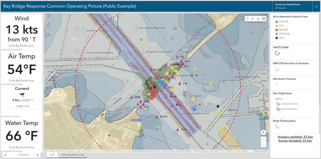
The data hub is a single location for response assets to be able to access authoritative data and tools made available by partnered agencies. Data are viewed or accessed through several dashboards and applications, or through individual categorized repositories. Users can access the data in these repositories and download it to support distinct needs. Additionally, geographic information system specialists created dashboards or applications for specialized requirements, such as a salvage dashboard with real-time dive safety zones, vessel locations, and both wind and water current information to advise safe salvage operations.
Multi-Agency Response
In federally managed waters such as the Port of Baltimore, while many agencies have jurisdiction over the waterway, they each share the common goal of safe and efficient movement of vessel traffic and commerce.
In the case of the Key Bridge collapse, multiple agencies played a key role in the reconstitution of the port.
- The U.S. Army Corps of Engineers has responsibility for federally managed shipping channels, including dredging and surveying.
- The National Oceanic & Atmospheric Administration is charged with surveying all navigable waters outside of federal channels and with creating the navigation charts and publications for the United States.
- The U.S. Coast Guard marks the federal waterways with aids to navigation, keeps the public informed about waterway-related interests through Local Notice to Mariners, and provides response to instances of distress or improper activity. Also, the Coast Guard’s Captain of the Port is charged with ensuring safe function of the port and has the authority to open and close it as necessary.
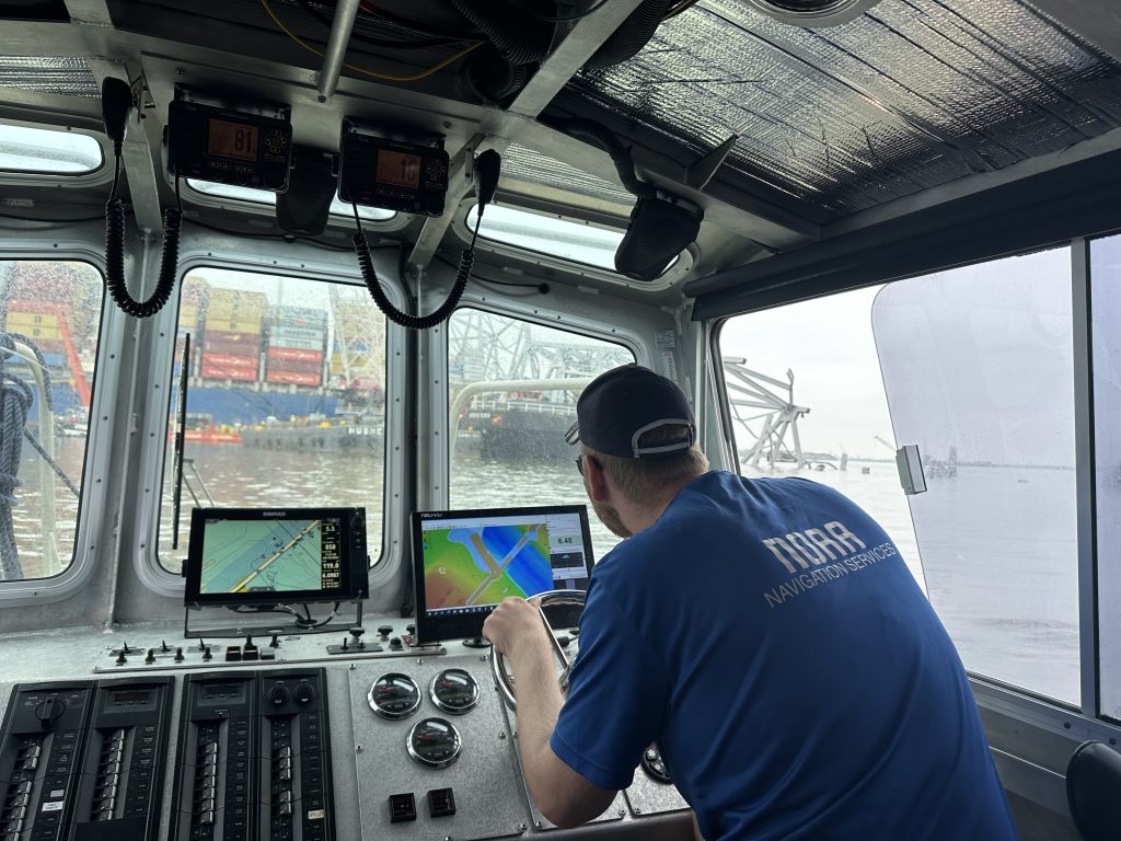
During the Key Bridge response, these agencies deployed multiple assets including survey, law enforcement, aids to navigation maintenance, salvage, and support vessels as well as Unmanned Aerial Systems and manned aircraft equipped with survey and monitoring equipment. The ICP was able to monitor all these vessels remotely through the Automatic Identification System by supplying data from Maryland’s Department of Natural Resources terrestrial identification system and marine radar system through the Department of Information Technology’s GIS resources.
These tools enabled real-time deconfliction as multiple salvors and recovery support assets worked numerous objectives simultaneously. The end result: completion of the most complex salvage operation in history, in record time, and with zero injuries.
The COP and the data hub provided immediate value through enhanced situational awareness across all response organizations and the improved conflict resolution and decision-making. Conducting dredge operations, for example, was being contemplated in an area with a known pipeline present. Comparing the surveyed location of the pipeline with the proposed dredge areas in the data hub’s Planning Application ensured the safety of the utility asset, the environment, and the overall operation.
Putting Data to Action
A fundamental interest to the port partners and Unified Command was establishing temporary access channels to reopen the flow of commerce, which was assigned to the Coast Guard Marine Transportation System Recovery Unit (MTSRU).
MTSRU partners from the U.S. Army Corps of Engineers and the Office of Coast Survey within the National Oceanic & Atmospheric Administration were delegated survey areas in the safety zone in order to identify prospective channels and to ensure no dangers to navigation existed in those channels. Data from the field units was uploaded to their parent agency AGOLs and made accessible to the COP and data hub. From this single access point, the MTSRU and Unified Command were able to designate channels and deploy vessels to mark them eight days after the incident, all while updating the entire ICP to these developments through the COP.
Collaboration on GIS tools like the COP designed to support the Key Bridge recovery effort represent the future of emergency response data management. Going from printed siloed data products to a centralized access point and designed visualization schema has increased the decision-making tempo and accuracy. This was evident in the speed of channel openings, the recognition and resolution of operational conflicts, and the unprecedented safety record of the response.
Informing Incident Commands
The partner agencies providing data to the COP for the Key Bridge continue to work together to ensure that the methods and procedures developed in Baltimore are captured for future responses and that geospatial tools can be made available to future incident commands.
Leveraging GIS can help better inform inter-agency response operations with an eye toward reducing the impact of both natural and anthropogenic disasters in the future.
Lt. Patrick Debroisse, CMH-A, M.SAME, NOAA, is Operations Officer, NOAA Ship Ferdinand R. Hassler; patrick.j.debroisse@noaa.gov.
Lt. Cdr. Ian Hanna, USCG, is Maritime Transportation System and Aids to Navigation Officer, Coast Guard District Five; ian.s.hanna@uscg.mil.
Article published in The Military Engineer, September-October 2024
More News from TME
-
Leading the Way: Partnering for Resiliency and Readiness
TME Interview with Brig. Gen. Patrick Miller, P.E., F.SAME, USAF Commander, Air Force Civil Engineer Center -
Developing Tomorrow’s STEM Workforce Through Partnership
TME recently interviewed leaders of the Panama City Post about paying it forward, their repertoire of STEM outreach, and the benefits of collaborating with similar-minded professional organizations. -

Electrifying Solutions for Military Installations
As military installations implement electrification measures into the future, the challenges they face will not just require innovative technology solutions but embracing a holistic delivery approach implemented early in projects.