By Col. Patrick Coullahan, P.E., PMP, CFM, F.SAME, USAF (Ret.)
In the defense of the United States homeland from the threat of missile attack, the Alaska region has served an outsized role. Its location close to the Arctic has made it a strategic line of defense for both missile detection and deterrence missions.
The history of missile defense on Alaskan soil dates back nearly 70 years, beginning in 1954 with the planning and installation of Nike Ajax missiles. As capabilities in intercontinental ballistic flight, radar, and electronic sensing have evolved, missile defense activities in the Last Frontier have evolved as well. From the earliest air defense systems constructed at the start of the Cold War, to the modern, state-of-the-art facilities hosted within the state’s borders today, Alaska has played a pivotal role in America’s missile defense—and that responsibility remains just as vital as ever.
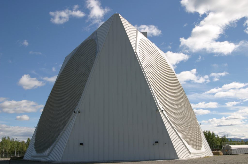
EARLY WARNING SYSTEMS
The Distant Early Warning Line air defense system (DEWline) was built during the Eisenhower Administration, and provided a string of radar detection stations in the Arctic. In the event of a surprise attack from Soviet bombers, the system would provide Americans with three or four hours to prepare for an oncoming assault. Construction of the first phase of the DEWline began in 1953 and was completed in 1957.
By 1961, however, it was recognized that a potential attack would more likely be delivered by ballistic missiles, not bombers, which were beyond the capabilities of the DEWline and Aircraft Control & Warning stations. To mitigate this, a Ballistic Missile Early Warning System (BMEWS) was quickly based 75-mi south of Fairbanks at Clear AFS, an installation carved out of an ideally situated location, with three main areas developed. The Tech Site included the BMEWS radar and related buildings. The Composite Site had the support facilities such as dormitories, recreation facilities, and warehouse and was connected to the Tech Site by an enclosed utility corridor. And the Camp Site provided base operation facilities not directly associated with the BMEWS— delivering a complete and useable system for the nation.
Compared to what is available today, the complex at Clear AFS was designed with rather primitive tools. Consisting of three antennas measuring 165-ft by 400-ft (larger than a football field), the electronic detection system was a marvel of its time. Information from BMEWS was transmitted, simultaneously, to display screens at U.S. Northern Command Headquarters in Colorado, Strategic Air Command Headquarters in Nebraska, and at the Pentagon. Complemented by microwave and cable communications equipment, the $360 million BMEWS could give at least a 15-min warning to bombers based at Strategic Air Command, in America’s heartland. Among the design criteria was that its antennas would be able to withstand magnitude 7.0 earthquakes and winds of 180-mph.
The main reception and transmission element to this radar was the AN/FPS-92 tracking radar, which was a 82-ft diameter parabolic reflector mounted on a conical pedestal that rotated to track or search continuously to detect targets. It was protected by a 141-ft diameter Radome. The second radar was AN/FPS 50—a large static radar that used three tall parabolic reflectors fed by organ-pipe scanners.
From the three radar billboard antennas, two electronic beams fanned the atmosphere at differing angles. The radar pulse from objects passing through the beam closest to the horizon was fed to computers to determine position and velocity. Data from the second beam determined speed, trajectory, point and time of impact, and launch point. The use of sophisticated Klystron tubes allowed for the computation of trajectories on launch and target points—a tremendously important advancement in capability.
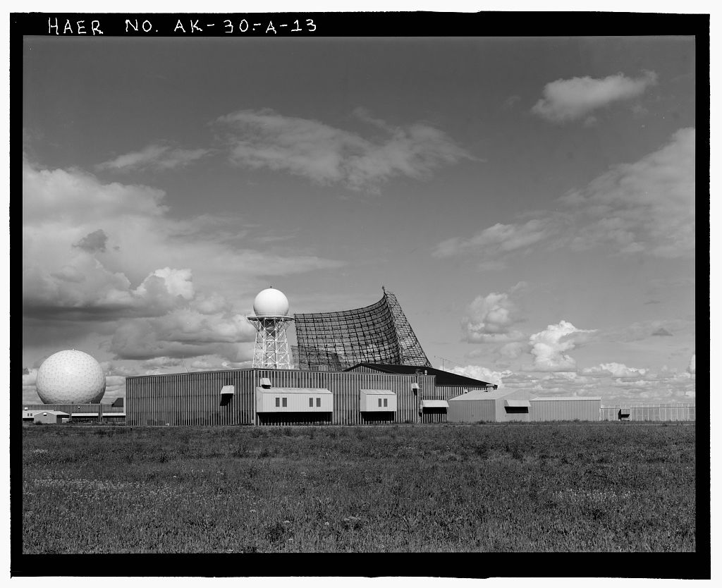
threats. PHOTO COURTESY LIBRARY OF CONGRESS
FROM DETECTION TO DEFENSE
By 1989, while the Soviet Union had collapsed, the threat of ballistic missile attack from rogue nations such as North Korea, which had launched the three stage Taepodong I missile in its attempt to place a satellite in orbit, remained. Recognizing Alaska’s strategic location for missile detection and defense, key components of the Ground-Based Midcourse Defense (GMD), originally the National Missile Defense, were planned to be based in Alaska. In August 1999, President Clinton authorized a plan to place missile interceptors on Alaskan soil by 2005.
In June 2002, after a tremendous effort that comprised new technology, specialized engineering designs, significant construction challenges, and impressive logistics needs, formal groundbreaking ceremonies for the Alaska-based GMD assets were held at Fort Greely. This coincided with planning and work already underway at Eareckson AFS on Shemya Island in the remote Aleutian chain, 1,500-mi from Anchorage.
Though other components of missile defense were advanced elsewhere, the GMD hit-to-kill system was to be the mainstay of U.S. efforts. In 2004, Alaska became home to a significantly advanced Ballistic Missile Defense System, complete with personnel, command and control, security, interceptors, sensors, electromagnetic pulse resistant infrastructure, power, facilities, and dedicated logistics. By July 2004 the Ground-Based Missile Defense Complex was dedicated at Fort Greely and the Alaskan system was declared ready to deploy.
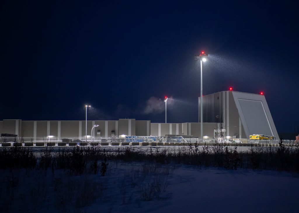
REMAINING WATCHFUL
Improvements and upgrades in radar detection were also advancing during this era. The U.S. Air Force’s largest military construction project for FY1998, costing $106.5 million, was the Clear Radar Upgrade Program (this effort utilized existing radar components from the deactivated phased array PAVE Phased Array Warning System Submarine Launched Ballistic Missile warning site at El Dorado, Texas). The multiyear project avoided the acquisition of an entirely new radar system at a cost savings of $140 million. Construction for the relocated radar facility was administered by the Alaska District of the U.S. Army Corps of Engineers.
Even as this system came online, the need to have upgraded sensors was apparent to leadership with the Missile Defense Agency. At Eareckson AFS in 2004, the Cobra Dane Radar, which had originally been built in 1976, saw significant upgrades to provide the first line of defense. Many powerful system improvements were similarly made at Clear AFS by 2012.
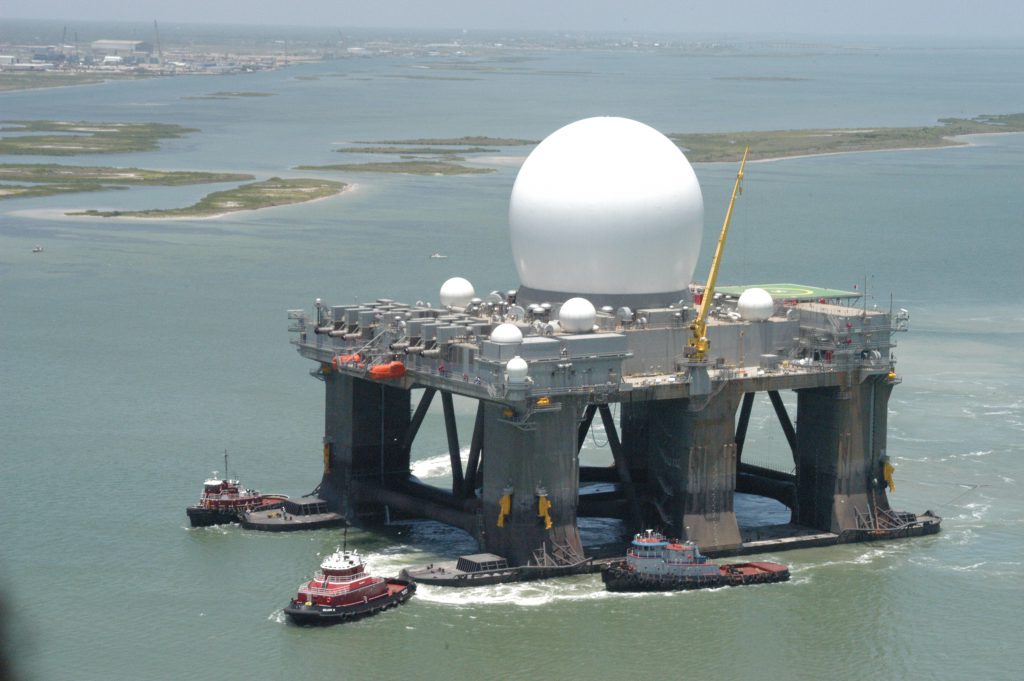
Eareckson had also been slated as the site for construction of the X-Band Radar at the beginning of the millennium. However, a more opportunistic view was established to change that basing concept to the Sea Based X-Band (SBX) Radar. Built on a mobile, ocean-going, semi-submersible platform and nominally homeported at Adak, Alaska, this new asset was sent to an improved basing in Hawaii at Pearl Harbor to assist in testing flexibility.
Able to acquire, track, and discriminate the flight characteristics of ballistic missiles, SBX provides an advanced capability to the Missile Defense System, increasing the Missile Defense Agency’s ability to conduct operational and realistic testing of the system while providing an operational capability to the combatant commands. The mobility of the platform enables the radar to be repositioned as needed to support various test scenarios.
The latest radar system to be fielded on Alaskan soil is the Long Range Discrimination Radar, which can search and track multiple small objects in space and determine the lethality or non-lethality of each one. This flexible and robust system will assist monitoring of space and enable a better defense of the United States from ballistic missiles and growing hypersonic missile threats.
To construct the Long Range Discrimination Radar required a series of utility, facility, and other infrastructure upgrades in the unforgiving Alaskan environment. Work included site demolition and preparation, extensive logistics, and security requirements, as well as the complications arising from the COVID-19 pandemic. These challenges were met head on by an outstanding team of operators, engineers, contractors, logisticians, and many others, in a manner reminiscent of the past collaborative efforts to build the DEWline, BMEWS, and the initial beddown of the GMD Alaskan-based systems.
A STRATEGIC LOCATION
As the world continues to witness new threats, securing our airspace from the threat of missile attack remains as critical—if not more so—than in the 1950s when the first warning stations were constructed across the Arctic.
Having the ability to base much of our missile defense efforts in Alaska is an ideal situation. As the United States continues to address the evolving challenge of missile threat, our northernmost state will no doubt continue to play a pivotal role in the expansion and improvement of our nation’s capabilities for years to come.
Related Posts
-
Leading the Way: Partnering for Resiliency and Readiness
TME Interview with Brig. Gen. Patrick Miller, P.E., F.SAME, USAF Commander, Air Force Civil Engineer Center -
Developing Tomorrow’s STEM Workforce Through Partnership
TME recently interviewed leaders of the Panama City Post about paying it forward, their repertoire of STEM outreach, and the benefits of collaborating with similar-minded professional organizations. -

Electrifying Solutions for Military Installations
As military installations implement electrification measures into the future, the challenges they face will not just require innovative technology solutions but embracing a holistic delivery approach implemented early in projects.