By Ike Pace, P.E., Doug Bell, P.E., Fernando Cuenca, Ph.D., P.E., G.E., and James Costello, P.E., M.SAME
Following issuance of a Chief’s Report, a project to provide flood protection for the Westminster watershed in Orange County, Calif., utilized a unique funding plan and a progressive design-build approach that allowed for the incorporation of cutting-edge technology to meet updated guidelines and reduce seismic impacts.
In 2020, the U.S. Army Corps of Engineers, in partnership with the Public Works Department of Orange County, Calif., published a flood risk management study that evaluated the Westminster watershed, the largest remaining floodplain in the county. This study led to a Chief’s Report, which offered actions aimed at mitigating the risks to life safety and property damage for residential, commercial, and public structures.
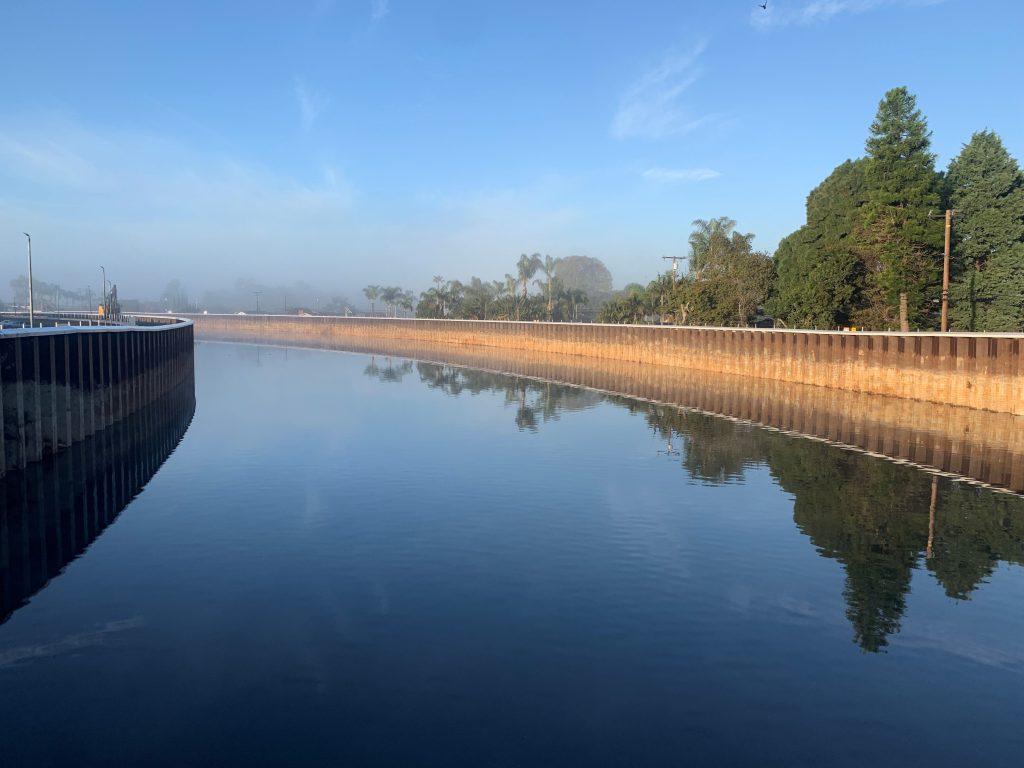
Among the recommendations in the federally issued report was upgrading the East Garden Grove-Wintersburg Channel. Located in Huntington Beach, the channel is roughly 1-mi long and was originally an eroded earthen, trapezoidal channel that consisted of a 70-ft base, 2:1 side slopes, and a levee height of approximately 11.5-ft. The planned upgrades to the channel would accommodate 100-year storm discharges, address levee erosion concerns, comply with regulatory agency requirements, and mitigate the risk of a levee failure.
Orange County elected to move ahead with funding the project entirely independently—a strategy that advanced it ahead of other planned projects within the broader Westminster watershed study. Importantly, though, throughout the work the channel was designed and constructed to be “integral” (as defined in section 221(a)(4) of the Flood Control Act of 1970) to a potential federal project covering the entire watershed. This distinction would enable future reimbursement to the county as part of the cost-share for the overall watershed study.
Community Protection
A primary objective of the channel upgrade is to eliminate the floodplain while also improving it to current design standards. The original channel design had aimed to handle 65 percent of the 25-year storm event. That is roughly equivalent to a 10-year storm event today. A risk and uncertainty analysis was performed as required for all flood damage reduction studies based on Engineering Manual 1110-2-1619, Risk-Based Analysis for Flood Damage Reduction Studies, and Engineering Register 1105-2-101, Risk Analysis for Flood Damage Reduction Studies. These analyses confirmed the channel capacity had fallen short of meeting the current design criteria of providing 100-year flood protection.
Mitigating Impacts. Located within a region plagued by high groundwater near the coast, there was a substantial risk that flooding would affect surrounding residential properties. Additionally, through the process of driving the sheet piles and installing the soil cement-mixed columns as part of the project, there was a possibility of altering the natural groundwater movement in Huntington Beach. To assess this, the project team conducted a 3D groundwater study examining the possible groundwater effects during high-water flow and normal water flow. This examination showed the project would not significantly impact the natural groundwater table, either by raising or lowering it.
The reissued engineering manual from the Corps of Engineers (1110-2-1619) concerning conduits, culverts, and pipes emphasizes the need to reduce, minimize, or eliminate penetrations. Consequently, this aspect was reassessed during the project and led the team to define an alternative method to handle interior drainage and eliminate storm drain penetrations. The solution was an adjacent underground detention and infiltration gallery that eliminates all levee penetrations.
Streamlining Delivery
While the Orange County Public Works typically uses design-bid-build, the channel project was the first to utilize a progressive design-build approach. This gave the county greater participation in the design process. Input was provided to the designer (Tetra Tech) and the builder (JF Shea), and feedback was incorporated before plans and specs were approved for construction.
At the halfway point of design, construction costs were submitted to the county, and the project was broken into two phases. The initial design phase included river hydraulic and groundwater analyses, geotechnical and structural engineering, and the development of construction documents. Concurrently, during this construction, the second design phase elements were incorporated to include fall protection, a maintenance road, landside access, runoff collection, and tie-back retaining walls beneath two bridges.
By phasing the project, the team was able to promptly procure steel sheet piles and cement and allow construction to begin on the first phase while the remainder of the design was being finalized. This speed proved critical. Material procurement happened just before the COVID-19 pandemic, which caused material prices to surge. Leveraging progressive design-build saved approximately 15 months in the schedule and a considerable amount of the budget.
This study led to a Chief’s Report, which offered actions aimed at mitigating the risks to life safety and property damage for residential, commercial, and public structures.
Addressing Constraints
The existing channel traverses a very tight right-of-way, with proximity to residential backyards, arterial roads, and bridges. Increasing the floodwater carrying capacity of the channel that also accommodated its current right-of-way posed a unique challenge.
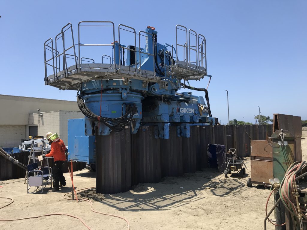
The team recognized the advantages of transforming the previously trapezoidal channel into a rectangle using vertically driven sheet piles. By also implementing sheet pile walls on the outside of the levees, the channel remained within the original right-of-way. This modification opened the channel and allowed for increased levee heights on both sides, increasing its conveyance capacity.
To carry out this modification, the use of a GIKEN Silent Piler was required. This machine grabs sheet piles and hydraulically presses them into the ground. Embracing this equipment played a crucial role in securing public approval for the project.
Alternate Approach. The structural team faced its most significant challenge when designing the two places where the channel crossed beneath bridges. Concerned that typical retaining wall abutment modifications might adversely affect the bridges, steps were aimed at providing the option of future replacement.
Numerous underground utilities within the right-of-way prevented the typical soil nail or tie-back of the concrete wall beneath the bridges. Instead, soil improvements were implemented within the roadway, and high strength tie-backs were anchored into those soil-improved zones. This approach reduced the number of anchors while minimizing any potential bridge displacement.
Raising Seismic Resilience
In addition to flooding and water management concerns, the project site lies near the Newport-Inglewood fault zone, which has the potential to generate a 7.4-magnitude earthquake. Beneath the channel, subsurface conditions include loose to medium-dense sands along with significant layers of highly compressible organic material. To enhance the channel’s resilience to earthquake shaking, ground improvements beneath the levee were recommended.
The original channel design had aimed to handle 65 percent
of the 25-year storm event. That is roughly equivalent to a
10-year storm event today.
The team researched historic earthquake impacts in the area and performed a rigorous seismic deformation analysis using PLAXIS. In the laboratory, soil samples were mixed with various amounts of cement to determine the material’s compressive strength. Ultimately, a compressive strength of 120-psi was established for the design of soil improvement.
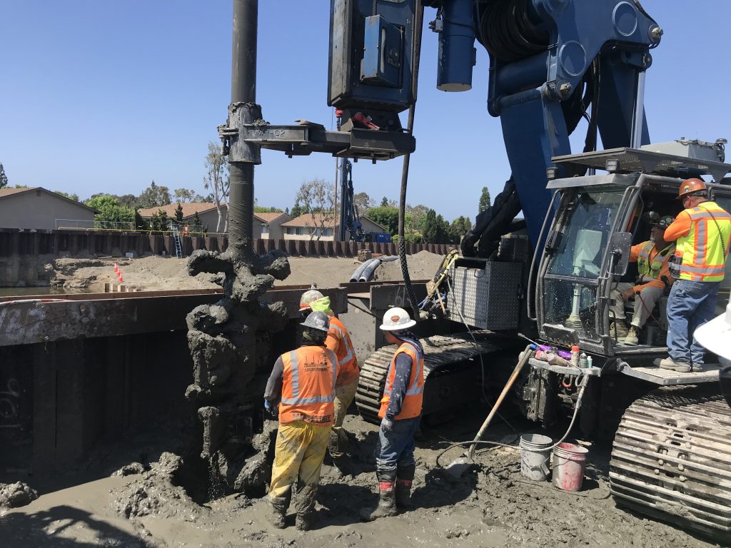
Following this analysis, the team implemented deep soil mixing. Large augers injected cement into the subgrade and mixed it with the soil at depths ranging from 40-ft to 50-ft below the levee. While this method was predominant, in areas of low clearance due to overhead electric lines, jet grouting was also employed.
Innovative, Adaptable
In Orange County and other densely populated regions, limits on a right-of-way pose challenges for acquiring sufficient land to create a more traditionally open channel. This floodplain project offers a unique approach to flood protection within a highly urbanized and constrained environment. It demonstrates methods to enhance the bond stress of tie-back anchors in poor soil conditions, adopting a state-of-the-art approach focused on deep soil mixing improvements, to create a channel that maximizes cross-sectional area for water flow without requiring additional right-of-way from the surrounding communities. While a reinforced concrete channel might have offered greater conveyance, the current channel features a soft bottom, allowing for the development of sandbars and vegetation.
Given rising coastal populations and threats of climate change, it is crucial to develop adaptable solutions that address floods, seismic events, and related challenges. Having a mindset to step past conventional approaches is what will drive community resilience.
Ike Pace, P.E., is Engineer of Record, Doug Bell, P.E., is Geotechnical Engineer, Fernando Cuenca, Ph.D., P.E., G.E. is Seismic Modeler, and James Costello, P.E., M.SAME, is Civil Engineer, Tetra Tech. They can be reached at ike.pace@tetratech.com; doug.bell@tetratech.com; fernando.cuenca@tetratech.com; and james.costello@tetratech.com.
Article published in The Military Engineer, July-August 2024
More News from TME
-
Leading the Way: Partnering for Resiliency and Readiness
TME Interview with Brig. Gen. Patrick Miller, P.E., F.SAME, USAF Commander, Air Force Civil Engineer Center -
Developing Tomorrow’s STEM Workforce Through Partnership
TME recently interviewed leaders of the Panama City Post about paying it forward, their repertoire of STEM outreach, and the benefits of collaborating with similar-minded professional organizations. -

Electrifying Solutions for Military Installations
As military installations implement electrification measures into the future, the challenges they face will not just require innovative technology solutions but embracing a holistic delivery approach implemented early in projects.