Asset Management
By Sam Briuglio, GISP, M.SAME
Asset management systems like BUILDER SMS provide extensive levels of data for facility managers, but for decision-makers tasked with making quick assessments, the advantages of a condensed and digestible approach provided by a geographic information system could better support those needs.

Federal organizations have multiple systems and data standards in place to help with day-to-day asset management operations and long-range decision-making. Some of these systems, including Maximo and BUILDER Sustainment Management System (SMS), can be powerful resources when implemented and sustained efficiently.
Together, these tools, practices, and data standards, along with their linkage to applications enabling geographic information systems (GIS) can help government agencies avoid “garbage-in/garbage-out” scenarios and streamline decision-making through more user-friendly data presentation. This can lead to fully auditable and executable products based on sound data and requirements.
In addition, while asset management efforts have proven in many cases to provide significant cost savings through updated real property inventories and best management practices, the data and systems produced can be cumbersome. Fortunately, there is opportunity to evolve asset management through the further implementation of GIS-based tools.
Platform for Progress
The amount of data produced from many asset management systems can be daunting—while the interfaces (although ideal for in-depth analyses) also can be complicated for leadership to use. Current asset management systems, such as BUILDER SMS and Maximo, have revolutionized asset management for facilities and infrastructure managers. However, the level of detail and data associated with their output can make it difficult to get to the bottom line of critical justification for facility changes.
Government stakeholders and facility managers are often under a tight timeline and constrained budget to digest a lot of information and make mission-critical decisions. Industry partners should support these needs by developing hybrids of services and technologies to help with quick, mission-essential determinations based on information that is easily disseminated and understood. This predicates using tables, graphics, and text, while also having a spatial component for context and presentation.
The ideal medium for solving this problem can come from the implementation of GIS-based platforms.
Evolving Capabilities. GIS has evolved extensively over the past decade. Significant improvements have been implemented in data dissemination and the development of decision-supporting tools. The application programming interfaces that are now available through GIS yield a powerful environment for personalized applications that can link to and draw from the dynamic sources and help tell a compelling story.
In addition, being able to link data directly to interactive maps helps managers orient decisions for a particular building or asset in a manner that is not only site-specific but may have impacts on collocated critical infrastructure as well.
Getting Data, Faster
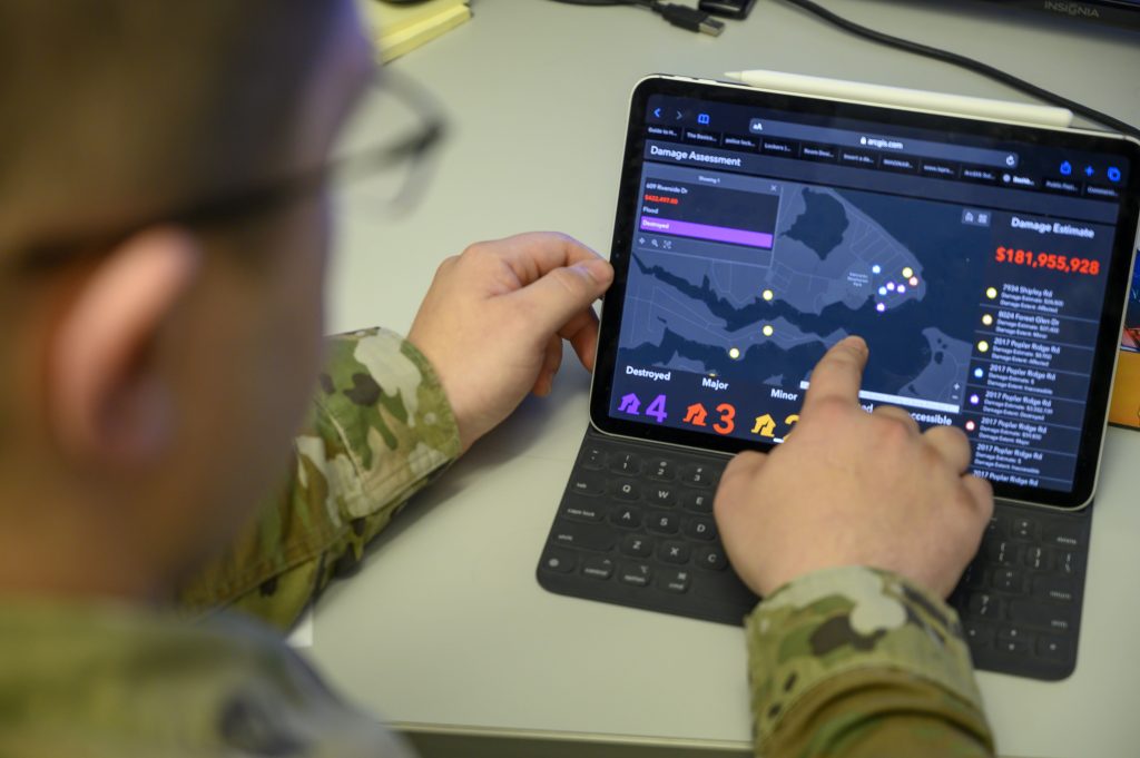
The implementation of interfaces and tools related to GIS can help to condense information, make it more visual, and bridge the gap needed to make well-informed decisions faster. As an example, consider how GIS can advance and optimize outputs from BUILDER SMS.
Developed by the U.S. Army Engineer Research & Development Center’s Construction Engineering Research Laboratory, BUILDER SMS is a web-based software application to help engineers, technicians, and managers decide when, where, and how to best maintain site infrastructure. The output from BUILDER SMS is a list of projects to update building components to extend the lifecycle of facilities. This can help installations more adequately maintain facilities instead of replacing them, or serve to better justify the replacement of a facility whose maintenance project list has surpassed its plant replacement value.
The reports from BUILDER SMS can be extensive, with some consisting of hundreds of pages of data. Facility managers need an option that provides a rollup of this data at a high enough level to make quick decisions, but with enough information to justify the proposed actions.
Balancing Priorities. GIS can enable a happy medium between the organic BUILDER SMS reports and an executive summary. In a recent example for a federal client, BUILDER SMS was used to collect and run analyses on building assets at locations throughout the continental United States. The output was analyzed and prioritized by facility planners into an auditable and executable project list that took a fiscally reasonable approach to project execution. This list then was developed into a database that was used to feed a GIS-based dashboard to dynamically analyze and present the data for decision-makers to use in a faster and more digestible format.
The end user can see the information numerically, through text explanations, charts, and graphs. They can interact with it at various scales through an interactive map viewer. In addition, the end user can analyze and present information in a visual manner that provides perspective of how a maintenance or building replacement decision affects the surrounding real property for more holistic mission-essential management.
Widening the Definition
A more abstract use of GIS in asset management may redefine the term “asset management” altogether. When we think of asset management, generally, it is in terms of physical assets related to buildings and infrastructure, such as the actual structures, primary components, support functions, and utilities. However, an asset can be anything owned or controlled by an entity where the item, whether tangible or intangible, can be used to produce positive economic value. By this definition, any building, component, utility, or other real property would count as an asset.
This definition would also include “assets” such as a master plan, design, or other decision-making document. We consider asset management applications to be tools that help identify dated or failing infrastructure whose updates will prolong a lifecycle to meet mission readiness without the need for replacement. The same holds true for planning and design documents.
Finding ways to develop hybrid approaches to data collection, analysis, dissemination, and even updates for asset management is an opportunity for professionals to collaborate creatively to find dynamic solutions to complex situations.
Consider military master plans. On average, military master plans are updated every seven years. Where many are out of date and call for a full revisit and development, there are others that have minor components that need changes to stay up-to-date and compliant (or, to extend their lifecycle).
Some recent master plan developments have seen the implementation of GIS application programming interfaces to develop them into truly living, updatable documents that are highly dynamic.
Digital Enhancements. As an example, digital base master plans prepared through the Middle East District of the U.S. Army Corps of Engineers for installations in Jordan and Saudi Arabia were developed in an interactive, GIS-based user interface for the purposes of update management, presentation, and decision-making.
As part of this project, a graphic user interface was built using an ESRI Story Map as the baseline design, then further enhanced with its Experience Builder. The application included a front-end with links to each of the region’s plans. This allows the user to choose the plan document they want to view, then navigate within the plan or jump to the next.
As the user navigates the plan, there are a number of interfaces and applications that enable a completely interactive experience, including text, charts, and graphics. Each master plan map (study area, existing conditions, land use) is fully interactive and dynamic with the ability to pan, zoom, and run spatial queries on data layers by clicking on map components. As the user gets to the preferred master plan layout, they can see the map layout build dynamically as they scroll through the plan components, watching the plan build out notionally over time. In addition, the user has the ability to make updates to the text, graphics, and plan and map layouts as the plan changes. This yields opportunities to make minor adjustments to the master plans to keep them up-to-date and compliant where only minor changes are needed to extend their lifecycle.
A Hybrid Approach
Current federal asset management systems provide a commendable level of complexity in their capabilities. However, while this level of complexity is welcomed by facility managers and site level leaders, higher-level decision-makers need a more digestible level of information.
Finding ways to develop hybrid approaches to data collection, analysis, dissemination, and even updates for asset management is an opportunity for professionals to collaborate creatively to find dynamic solutions to complex situations. We are in an exciting time with the constant evolution of technology.
The cross-pollination of GIS and other technologies with asset management applications should be a natural evolution and catalyst initiative to help the federal government consistently meet the challenges of mission readiness.
Sam Briuglio, GISP, M.SAME, is Senior Vice President, Planning and Geospatial, Pond; briuglios@pondco.com.
Article published in The Military Engineer, September-October 2024
More News from TME
-

Leading the Way: Partnering for Resiliency and Readiness
TME Interview with Brig. Gen. Patrick Miller, P.E., F.SAME, USAF Commander, Air Force Civil Engineer Center -

Developing Tomorrow’s STEM Workforce Through Partnership
TME recently interviewed leaders of the Panama City Post about paying it forward, their repertoire of STEM outreach, and the benefits of collaborating with similar-minded professional organizations. -

Electrifying Solutions for Military Installations
As military installations implement electrification measures into the future, the challenges they face will not just require innovative technology solutions but embracing a holistic delivery approach implemented early in projects.